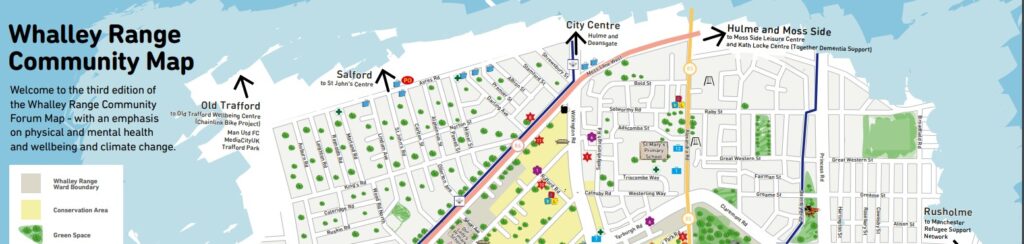
Welcome to the third edition of the Whalley Range Community Forum Map – with an emphasis on physical and mental health and wellbeing and climate change.
This map was produced by the Whalley Range Community Forum at JNR8 and was part-funded by buzz Manchester Wellbeing Service.
New 2 page MAP A3_v4 (4)
About this map: its history and previous versions…
In Spring 2011 local people voted yes to the idea of a map to celebrate the unique place that is Whalley Range.
A U Decide grant was awarded and, along with generous contributions from local sponsors and volunteers, the map has come to life.
The 2nd Edition features the regeneration of Alexandra Park along with updated listings, new history items and more.
The Whalley Range community map – started out as a U Decide proposal by Fiona Nicholls of the Forum’s Health & Sustainability group – and was successfully put forward to the community for votes for a share of a community grant in Whalley Range.
The first edition was produced in 2012 with a suggested donation of £1 – and any donations collected were fed back to the community groups and projects based at JNR8.
The map attracted a lot of interest – and a 2nd edition in 2013/2014 was funded by donations and sponsorship from local businesses.
The map exceeded all expectations in terms of how it was used: as well as an information resource (the map features stories and local history articles) the map was used by many of our community organisations and as part of our projects as a resource tool.
Our ESOL classes based some of their teaching sessions around the map with questions about the local area and a trip out identifying local key locations using a list of questions/directions – and a map to source the answers.
Maps have always been distributed at our community events and to new attendees to our classes and JNR8 events to help people to get around: when it was first produced it was not unusual to see people wandering around the local area armed with a map to locate some of the listed areas of interest with their children and visitors!
The Age-friendly Manchester launch featured a workshop from the Forum based around setting up an age-friendly network for older residents: the map was used to plan how to link up with people, as a ‘mapping’ exercise!
And for the Manchester Ageing Study – in partnership with the University of Manchester – the map was enlarged and used as a consultation tool for residents to identify where they felt safe, most visited areas, where benches should be sited etc.
The map – (along with several magnifying glasses for better accessibility!) – has always been a feature of our community events.
Copies of the map were posted in advance to different EU countries to our 16 participants of the Grundtvig workshop.
Students stayed in Whalley Range with host families for a week and attended a training session on positive numeracy and literacy teaching in deprived European communities. The students arrived from Manchester Airport armed with their maps to locate JNR8 and their host’s homes!
So as you can imagine the map has been a fantastic well used resource – and we were delighted that in association with Age-friendly Manchester – Fiona and the team produced our 3rd edition!
This version of the map focuses on mental and physical health and wellbeing, the age-friendliness of the area – and features local groups who are working with sustainability and green initiatives